Saturday, July 29, 2006

Satellite Images Reveal State of Health of World's Coral Reefs


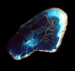
Image: Hawaii's Pearl and Hermes Atoll, shown here in a 20-mile-by-20-mile Landsat 7 image, is part of the recently designated Northwestern Hawaiian Islands Marine National Monument, the largest protected marine area in the world. (Credit: NASA)

A first-of-its-kind survey of how well the world's coral reefs are being protected was made possible by a unique collection of NASA views from space.

A team of international researchers using NASA satellite images compiled an updated inventory of all "marine protected areas" containing coral reefs and compared it with the most detailed and comprehensive satellite inventory of coral reefs. The global satellite mapping effort is called the Millennium Coral Reef Mapping Project and was funded by NASA. The study was reported on recently in the journal Science.

The assessment found that less than two percent of coral reefs are within areas designated to limit human activities that can harm the reefs and the sea life living in and around them. Countries around the world have created these protected ocean and coastal zones where human activities such as shipping, fishing, recreation and scientific research are restricted to varying degrees.

"The contribution of NASA images to this project was crucial," says study lead author Camilo Mora, a marine biologist at Dalhousie University, Canada. "The satellite images allowed us to pinpoint where coral reefs are actually located within coastal marine ecosystems."

The Millennium Project collection of global satellite images of coral reefs was first released in 2003; maps derived from these images were released in 2004. The images are now publicly available from NASA's Goddard Space Flight Center, Greenbelt, Md. Landsat 7 was designed by NASA and launched in 1999. The Landsat Program is a series of Earth-observing satellite missions jointly managed by NASA and the Department of the Interior's U.S. Geological Survey.

To achieve detailed, worldwide views of the very small and widely scattered reefs, the Millennium Project team analyzed nearly 1700 images taken by the Landsat 7 spacecraft over four years. Computer processing of these data resulted in the coral reef inventory and maps that revealed detailed information about the structure of individual reefs.

The new study found that while the number of marine protected areas has been increasing, the level of effective worldwide protection of coral reefs is small. The study also found that most protected zones are too small to provide protection for fish species that routinely swim outside the boundaries. Only a handful are big enough to protect fish and marine life that naturally range outside their boundaries.

"This research points out how much still needs to be done to protect coral reef ecosystems," said Frank Muller-Karger, one of the developers of the Millennium Project at the University of South Florida's Institute for Marine Remote Sensing in St. Petersburg. "Creating large reserves such as the new Northwestern Hawaiian Islands Marine National Monument is just such a step in the right direction." On June 15, the United States created the largest protected marine area in the world, which includes 4,500 square miles of relatively undisturbed coral reef habitat.

"Natural resource managers around the world and conservation groups actively use these coral reef satellite views to advance a wide range of habitat protection projects," says Serge Andréfouët, who developed the methods to create the Millennium coral reef maps. Andréfouët, co-author of the Science article, studies reefs with remote-sensing technology at the French Institut de Recherche pour le Développement in New Caledonia.

Source: NASA/Goddard Space Flight Center

Beaches of the World being trashed

This seems to be an ever increasing problem; the trashing of our beaches and it is happening around the world!

8 million pounds of trash plucked from world beaches

WEST PALM BEACH -- Cigarettes and their filters topped the list of trash items culled from beaches worldwide during last year's annual international coastal cleanup, according to a report.
More than 450,000 volunteers removed 8.2 million pounds of debris from 18,000 miles of coastline and waterways in 74 countries during the daylong cleanup in September, The Ocean Conservancy said in a report scheduled for release Thursday. The group has sponsored the worldwide volunteer effort for 20 years.

"Marine debris kills wildlife and is a threat to the local environment, not to mention an eyesore," said director Vickie Matter. "The information we've gathered over the past 20 years shows that it's ultimately a manmade problem, which means it is highly solvable."


This year's cleanup is set for Sept. 16.

You can read the story in its entirety here.

Monday, July 24, 2006

Scientists blame changes in West Coast climate patterns...

"Warmer Waters Blamed For Disrupting Food Chains"
Marcus Wohlsen, Associated Press

July 24, 2006 — On these craggy, remote islands west of San Francisco, the largest seabird colony in the contiguous United States throbs with life. Seagulls swarm so thick that visitors must yell to be heard above their cries. Pelicans glide.

But the steep decline of one bird species for the second straight year has rekindled scientists' fears that global warming could be undermining the coastal food supply, threatening not just the Farallones but entire marine ecosystems.

Tiny Cassin's auklets live much of their lives on the open ocean. But in spring, these gray-and-white relatives of the puffin venture to isolated Pacific outposts like the Farallones to dig deep burrows and lay their eggs.

Adult auklets usually feed their chicks with krill, the minuscule shrimp-like crustaceans that anchor the ocean's complex food web.

But not this year. Almost none of the 20,000 pairs of Cassin's auklets nesting in the Farallones will raise a chick that lives more than a few days, a repeat of last year's "unprecedented" breeding failure, according to Russ Bradley, a seabird biologist with the Point Reyes Bird Observatory who monitors the birds on the islands.

Scientists blame changes in West Coast climate patterns for a delay in the seasonal upwelling of cold, nutrient-rich waters from the ocean's depths for the second year in a row. Weak winds and faltering currents have left the Gulf of the Farallones without krill, on which Cassin's auklets and a variety of other seabirds, fish and mammals depend for food.

"The seas are warmer. And the number of krill being produced is lower," said Bradley as he held a Cassin's auklet chick, the only one from a study of 400 nests he expected to survive.

"Normally we would have hundreds," he said.


Read the rest of this important story here.

Saturday, July 22, 2006

Jellyfish Bloom on African Coast


Image by: Matko Biljak/Reuters/Corbis
A medusa floats in the sea near the Adriatic town of Split, Croatia. Medusae are one of the species of jellyfish responsible for the bloom on the Namibian coast.

Critics of the fishing industry have long predicted that if over-fishing continues for much longer, "junk species" like jellyfish will start filling up the vacancies.

Until recently, there was no evidence that the prediction would come true. But along the coast of Southern Africa, famously productive fisheries have crashed in recent years. In a new paper, English scientists say the spot on the food chain long occupied by these fish has now been filled by the largest jellyfish boom ever measured.

These jellyfish are said to be so dense that they cause trawling nets to burst at the seams. It is estimated that some 12 tons of jellyfish exist within the bloom.

It is also thought that this bloom could be part of a long cycle wjich has not been recorded; a cycle spanning 30 to 40 years between.

For more check it out on NPR.org.

Friday, July 21, 2006

Effects of Bottom Trawling on Deep-sea Ecosystems


Deep beneath the surface of our oceans, ancient forests of cold water corals, soft seapens, sponges and seawhips are in danger of destruction from a commercial fishing technique called bottom trawling. Throughout these ancient forest live more mobile animals such as sea spiders—lobster-like crustaceans live in sheltered crevices. In the softer sediments, a dynamic community of small worms and crustaceans exists. In the waters around the seamounts live large populations of fish, swimming in the constant currents. Many seamount-dwelling species are not found anywhere else, and it is believed that some are confined to only one or two individual seamounts!

Biologists have estimated that between 500,000 and 5,000,000 marine species have yet to be discovered, some dating back to prehistoric times. But these very species are in serious danger from the world's most destructive fishing practices. This is truly the last undiscovered wilderness left on the planet and they must be protected.

Seamounts are uniquely biodiverse mountains and mountain ranges that inhabit the topography of the ocean floor. They rise at least 1,000 metres above the surrounding seafloor. It has been estimated that there are tens of thousands of seamounts across the world's oceans: upwards of 800 in the Atlantic Ocean, with more than 30,000 believed to be in the Pacific Ocean. Amazingly, the Earth's longest mountain range is not on land but under the sea - the Mid-Oceanic Ridge, which winds around the globe from the Arctic Ocean to the Atlantic. It is four times longer than the Andes, Rockies, and Himalayas combined!These seamounts are hard surfaces that are colonised by colorful forests of attached cold water corals, soft seapens, sponges and seawhips.

The number one threat to this uniquely biodiverse area of Earth is bottom trawling and unfortunately, the commercial fishing industry has gotten to know about the rich pickings that exist in these deep waters. The industry has developed its boats and scaled up its trawl gear to enable it to extend its unsustainable fishing practices into previously unexploited deep waters and seamounts. Bottom trawling involves dragging huge, heavy nets along the sea floor. Large metal plates and rubber wheels attached to these nets move along the bottom and crush nearly everything in their path. All evidence indicates that deep water lifeforms are very slow to recover from such damage, taking decades to hundreds of years—if they recover at all.

Greenpeace International is campaigning for an immediate halt to high seas bottom trawling. If allowed to continue, the bottom trawlers of the high seas will destroy deep sea species, before we have even discovered much of what is out there. Think of it as driving a huge bulldozer through a lush and richly populated forest and being left with a flat, featureless desert. Think of it as beef farming by dragging a net across entire fields, cities and forests to catch a few cows. It's like blowing up Mars before we get there.

Incredibly, there are more maps of the moon than of the Earth's sea bed, and it has only really been over the last 30 years that we have got to know about the rich and complex world of the deep ocean. We have been fascinated by the discovery of water on Mars and its potential for life - but there is underwater life right here that could disappear before we even explore it.

If you would like to more about the destruction—and read sientific proof—done by bottom trawling, then check out and download (pdf) the Deep Sea Coalition’s “Bottom Trawling: RED HERRINGS

The Deep Sea Conservation Coalition (DSCC), a combined force of more than 40 conservation groups from around the world, is calling on the United Nations General Assembly to secure a moratorium on high-seas bottom trawling until a regime to protect deep-sea fisheries and biodiversity is developed and implemented. In an effort to fight this conservation measure, the fishing industry has made numerous fictitious claims aimed at downplaying the detrimental effects of bottom trawling on deep-sea ecosystems. These claims are easily refuted by the staggering amount of scientific evidence demonstrating the harmful impacts and unfortunate expansion of the bottom-trawling fishery from the shallow continental shelf to deeper and more distant waters beyond national jurisdiction. This document presents a compilation of the claims offered by the fishing industry, each followed by a powerful rebuttal based on the best available science.